Basking Lizard

Way back on July 3rd I took the day off from work and visited Dutch Gap Conservation Area (DGCA) to find birds, take photos and to practice digiscoping. While I was practicing the digiscoping with a pair of nesting birds as my subject, I noticed a lizard crawl out onto a nearby tree and begin to soak up some sun. I really did not need to use the digiscoping setup to get pictures of the lizard because it was much closer than the birds, but I also did not want to switch back to my regular photography setup just to get a picture of the lizard (it takes just enough time to be annoying, and is not something you can in a couple seconds).

So, here is the digiscoped lizard in all his glory. He is clinging to the side of a tree in a gravity defying pose, letting the sun re-energize him. Like all of my digiscoped photos, this one is not super sharp (but certainly not blurry). I am trying to figure out if that is user error, gear related, or just the norm for digiscoped photos.

Basking Lizard

Rapidan Loop

This past Sunday, Tammy and I hiked what I am calling the Rapidan Loop, in Shenandoah National Park. We also had a guest hiker: my friend Rich joined us.

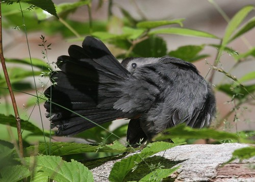
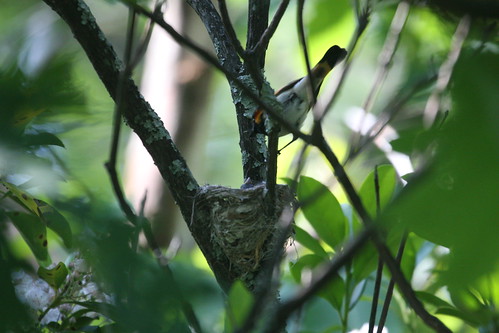
Sunday was a fantastic day. Lots of sun. Unseasonably cool. Gentle breeze. All in all, it was a great day for a hike.

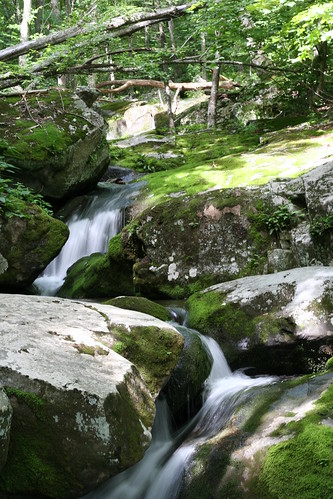
The Rapidan Loop, as I call it, is a 7.4 mile loop that starts at Milam Gap, milepost 53, on the 
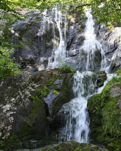
Skyline Drive. The first part of the hike follows Mill Prong Trail, which, in an amazing coincidence, parallels a stream called Mill Prong as it cascades down hill. This stream joins another stream, Laurel Prong, to form the Rapidan River. All this water ends up in the Rappahannock River and eventually the Chesapeake Bay.

Where the two "prongs" come together to form the Rapidan River is the former summer getaway of President Hoover, called Rapidan Camp. He would come here, sometimes with his entire cabinet and dignitaries, for summer vacations during his tenure in office. Now it is preserved as part of Shenandoah National Park. For those not inclined to hike down to (and back up from) the camp, there is a van that will shuttle you down to the camp from Big Meadows Campground. History buffs would definitely enjoy the tour, graciously provided by a resident park ranger.

To complete the Rapidan Loop, we left Rapidan Camp along the Laurel Prong Trail, following Laurel Prong upstream. Where the Laurel Prong Trail ends at the Appalachian Trail, turn north and follow the Appalachian Trail back to Milam Gap.

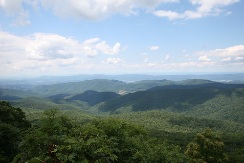
Once you leave Camp Rapidan, you are climbing back up to the elevation of Skyline Drive, and then higher as you cross the summit of Hazeltop, the third highest peak in Shenandoah National Park. The last mile or two of the hike is a gentle descent from Hazeltop's summit down to Milam Gap. At the summit of Hazeltop, there is a nice stopping point where you can gaze into the hills and valleys to the west of the park.

View from Hazeltop

Fungus Among Us

On the last leg of the Dark Hollow Rose River loop, a spot of color just off the trail caught my eye. It was a bright orange colored fungus growing on a decaying log. At least, I think it is safe to call it a fungus. I am not too familiar with the classification of mushrooms, lichens and things of that sort. I did spend some time searching Google, with search phrases like "orange shelf fungus" and "big orange lichen", but just did not find something that seemed to clearly match what I saw. The closest I found was a mushroom called Chicken of the Woods (because it supposedly tastes like chicken...you could have a nice T-Rex and mushroom soup, and it would taste very much like chicken soup), but I am not convinced that was what I saw growing on that log.

Orange Mushroom
Orange Mushroom

Babbling brook

After descending past the Dark Hollow Falls, you can follow the Rose River Loop Trail (change the map type from "G. hybrid" to "USGS topo") along the Hogcamp Branch. This is a fairly gentle descent towards the point where the Hogcamp Branch joins the Rose River. The Rose River is part of the Rappahannock River watershed, and its waters ultimately end up in the Chesapeake Bay. For the most part, the Hogcamp Branch is running parallel to the trail. In typical mountain stream form, it provides frequent chances to see water running over rocks of various sizes.

I am sure the description in that previous paragraph is much more bland that the real thing. There is just something so very relaxing about the sound a mountain stream makes as it winds its way through, over and around the landscape. Every chance I get to watch and listen just makes me want to package it up and take it home with me. But, unfortunately, all I can do is take a picture and try to remember that sound.

Hogcamp Branch

Deer

Whenever you enter Shenandoah National Park, whether driving, biking or hiking, you are likely to see at least one deer. In my experience, this likelihood increases the closer you are to one of the campgrounds in Shenandoah, like Big Meadows [pdf]. My theory is that there is a lot more food available for the deer where groups of humans spend lots of time. In other words, our trash and handouts are like a big convenience store for the deer (and other animals). Keep in mind that I have not done anything scientific to test my theory (like actually counting deer at various distances from campgrounds). Nor have I actively considered other variables that might be at work here (variables other than the misdirected kindness and general negligence of humans). So, at this point, my theory is nothing more than blog fodder.

And a segue for cute deer pictures.

These are White-tailed Deer. All of these pictures were taken while Tammy and I were on our recent Dark Hollow Rose River Loop hike, which is coincidentally near the Big Meadows Campground.

White-tailed Deer
White-tailed Deer
White-tailed Deer

Questionmark

When we got to the Rose River Falls on our hike a couple weekends back, we took a few moments to catch our breath. We were in the middle of the climb back up to the Skyline Drive, so we needed the rest. But there were also the falls to look at, and about a dozen butterflies in and around this one tree next to the trail. Most of them were Red Admirals, but there was at least one Question Mark.

That's right. There is a butterfly named after punctuation. Actually, there is another butterfly that looks very similar to the Question Mark called an Eastern Comma. So that would be at least two butterflies named after punctuation. Not sure if there are any more.

The Question Mark gets its name from the underside of its wings (see the second picture). The underside is much browner, and cryptically patterned. In the pattern, however, is a small question mark shaped white line. It is really a small white curve with a white dot next to it. On the Eastern Comma (not pictured, but follow the link above to see someone else's picture) there is no white dot, but there is still a hooked white curve. There are other differences between the two on the top side, with the pattern of black dots on the orange wings.

The first picture here shows the top side of the Question Mark. The second picture shows the Question Mark with its wings "up", giving you a blurry glimpse of its signature field mark (look towards the back of the near wing and you will see the curved white line and white dot on the brownish wing).

Yeah, it is something of a reach to say that the white curve and dot look like that thing you put at the end of a sentence that asks a question. Right???

Question Mark
Question Mark

Preening Gray Catbird

Near the beginning of our hike on the Dark Hollow Rose River Loop, as we were switch-backing down to the Dark Hollow Falls, a couple of Gray Catbirds were flitting about in the bushes next to the trail. As we came around one of the switchbacks, one of the pair stopped in a nice, sunny spot and decided it was a great place and time for a bit of preening. I stopped and watched, happy at the chance for some photographs of a bird that was not flying away. My favorite is the third photograph below, where the bird looks like it is in the middle of some type of Japanese traditional dance.

Gray Catbird
Gray Catbird
Gray Catbird

American Redstart at nest

Here is one last photo from the Sugarloaf hike. Very early in the hike, we stumbled across the nest of an American Redstart. It was right next to the trail, but since the trail does not get much traffic, I suspect that the few people who get near the nest just walk on by, not even noticing it. We lingered for a few minutes, a respectable distance away, while I attempted to get a picture of an adult feeding a nestling. The adults, however, did not give me much time to take a photo (I imagine their priorities were a tad different from mine). They would bring in some tasty morsel, quickly give it to one of the nestlings, and then be off again in search of more food. The photo below is the best I could muster under the circumstances, factoring in that I did not want to linger too long for fear of distressing the adults.

American Redstart at Nest

Dark Hollow Rose River Loop

Yesterday, Tammy and I took advantage of the weather and hiked another loop within Shenandoah National Park. For this outing we combined a couple of well known hikes to waterfalls into a loop that was just under 6 miles long.

Near the Big Meadows Campground and Byrd Visitor Center [pdf], the Dark Hollow Falls hike is one of the more popular hikes in the park. It is short, but steep, and gets you to a series of three waterfalls (depending on how far down the hill you want to hike). Even further north of Big Meadows is the Rose River Loop Trail, that gets you to another set of falls.

When you hike down to the very bottom of the Dark Hollow Falls trail, you intersect with the Rose River Falls loop. So we combined the two into one hike. We started at the Byrd Visitor Center, hiked over to, and down, the Dark Hollow Falls trail. At the bottom of the Dark Hollow Falls Trail, we picked up the Rose River Loop Trail and hiked that until we got back to the Skyline Drive near Fisher's Gap, a few miles north of the visitor center. Finally, we took the Skyland-Big Meadows Horse Trail from Fishers Gap back to the visitor center.

If you would prefer to see that route on a map, then go here for just that, courtesy of my GPS.

Of course, I got lots of pictures on the way, especially of waterfalls. In the near future, my favorite pictures from this hike will be showing up in this blog. This one is of Dark Hollow Falls.

Dark Hollow Falls