We were both already thinking about the boat trip we had booked in Seward. We were excited about the possibility of seeing whales, and puffins, and glaciers and, and...
But we had to wait. It was like Christmas. There was this shiny gift under the tree, but we had to wait two more days to open it. So, on our second day in Anchorage we considered our options and ultimately decided to visit Hatcher Pass. This was not something we had planned to do months in advance, but something decided the night before. We had mulled through a list of things that caught our attention and somehow ended up with Hatcher Pass. I am not sure at all what it was that led to that decision, but that is where we ended up going. It was nice being flexible and making "game time decisions", but that approach also has some downside to it. More about that below.
View Larger Map
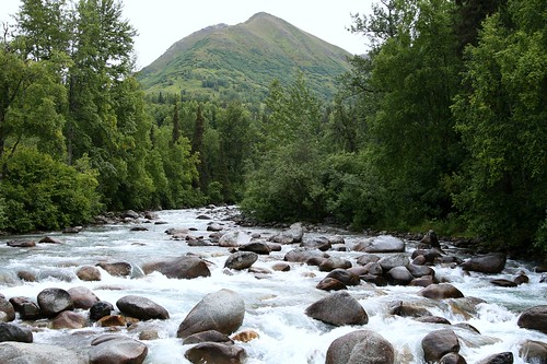
Hatcher Pass is located in the Talkeetna Mountains, north of Anchorage. As you enter the Talkeetna Mountains, the road begins to parallel the Little Susitna River (not to be confused with the "regular" Susitna River, a bit farther to the west) as it tumbles down to Cook Inlet. We took advantage of the scenic opportunities with the river that were provided to us.
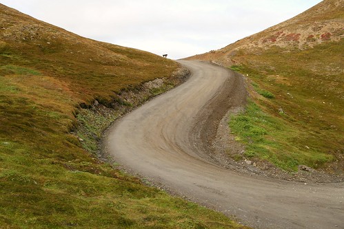
Eventually you turn off the paved road onto a gravel and packed dirt road. This is the road that actually takes you through Hatcher Pass. It isn't maintained once the snow starts falling, and thus usually gets closed in late September until the following June or July. There were lots of potholes, which made for quite the bumpy ride.
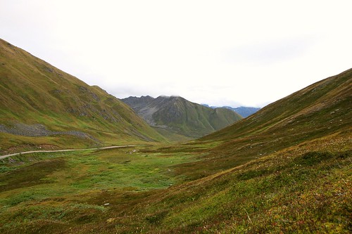
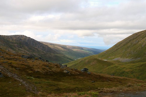
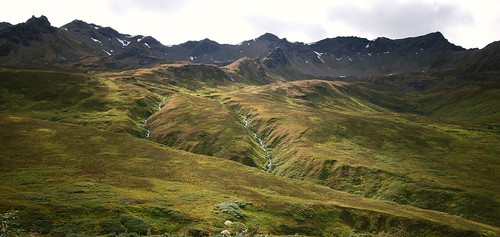
Hatcher Pass was beautiful. The views were stunning (even on a cloudy day). When we got out of our car and just listened, the silence was amazing. The only thing I heard was the hum of my aging ears. No cars, planes, music, or other people. Every now and then we would hear some animal or bird, but otherwise this place has become my new standard for "quiet".
We got out of the car to explore a couple of times, but unfortunately we were not prepared for much more than that. Had we done more research, we would have known that there are several hiking trails located at Hatcher Pass, that took you up a little higher on the mountains next to the dirt road. These were easy hikes that, out of ignorance, we simply had not prepared for. We would have definitely taken the time to explore those trails had we known. Without exploring the trails, I still found it difficult to pull myself and my camera away from the views and the carpet of lush growth on the mountain sides.
Just beyond Hatcher Pass you come to tiny Summit Lake. We explored here and tried to capture the quiet beauty of this lake with our cameras.
While we explored, the quiet was interrupted fairly regularly by nearby critters. There was some type of varmit hanging out on nearby rocks, making this squeaking noise. Varmit, of course, is technical jargon for something that looked like a marmot or ground squirrel. It had four short legs, was furry all over, made me think of Ewoks, looked like it might be willing to take food from a human, and seemed to call an underground burrow its home. And it was squeaky.
Then there were the Ptarmigans. On the rocky side of the mountain above us there was a flock of Ptarmigans. They were fluttering about, moving from roost to roost, making all kinds of interesting noises. The noise that was the most memorable to me was a frog like groan sound. I have not been able to find a recording on the web that matches the sound I remember (which is more likely a factor of my memory than the recordings on the web). I had my binoculars with me, but my scope sat back in the hotel room (sigh). Beyond the fact that I was seeing and hearing some type of Ptarmigan, I was unable to conclusively identify them as one of the three Ptarmigans that occur in North America (Rock, White-tailed or Willow...that sound I remember seems to be closest to White-tailed). Any of them would have been a lifer for me. Another example of where some more planning might have saved me some frustration.
Never mind that. Look at the beautiful views!
The ride down the opposite side of Hatcher Pass continued to be very scenic. To a point. Somewhere in the drive down to Willow it turned from scenic Alaskan valley into a very bumpy, pothole filled drive through a forest.
Hopefully this post did not come across too negatively. I am absolutely happy we visited Hatcher Pass, even with some of the frustrations. It is one of the most beautiful places that I have ever seen. On some future trip to Alaska, if I had the chance to visit Hatcher Pass again, I would come better prepared: plan to hike, plan to bird watch and don't bother driving down the far side of Hatcher Pass to Willow (just turn around at Summit Lake).
Showing posts with label I Can See For Miles. Show all posts
Showing posts with label I Can See For Miles. Show all posts
Snake River
A couple posts back, I talked about the mountains of Grand Teton National Park. One of the other prominent features of the park is the Snake River. The Snake River originates in Yellowstone National Park, and flows south into Grand Teton National Park before turning west towards its eventual consumption by the Columbia River. It is a giant river system, with numerous dams constructed on it (I counted at least 20 when I read the Wikipedia page) to provide navigation, irrigation and electricity.
Here are two photos that include the Snake River as part of the scenery. These may be repeats from the Blog Action Day post, but since they were not previously described as pictures of the Snake River, I figured it was okay to show them again. On another note, I think I have reached the end of my posts about the recent trip to Yellowstone. My next post should jump back to things closer to home.


Here are two photos that include the Snake River as part of the scenery. These may be repeats from the Blog Action Day post, but since they were not previously described as pictures of the Snake River, I figured it was okay to show them again. On another note, I think I have reached the end of my posts about the recent trip to Yellowstone. My next post should jump back to things closer to home.


Inspiration Point
There are a lot of trails in the vicinity of Jenny Lake, within Grand Teton National Park. There is even a ferry service across the lake if you want quick access to the far side. One of the popular destinations on the far side is Inspiration Point. There is a waterfall (aptly named Hidden Falls) on the way up, and the views from Inspiration Point are pretty nice. We ended up hiking to the far side, up to the waterfall and Inspiration Point, and then taking the easy boat ride back.
Part of the trail up to Inspiration Point is literally cut into the side of a short rock face. What is weird is that this caused me zero anxiety (unlike the trails that meandered next to the giant canyons of Yellowstone National Park). Tammy, on the other hand, was the exact opposite. She had no problem the meandering canyon-side trails, but the climb up and down from Inspiration Point was not quite as inspirational to her as it was to me.
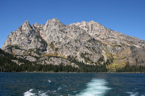
The first photo here is of a shadowy Hidden Falls. The second is one of the views from Inspiration Point, looking east across Jenny Lake. The third photo is Tammy negotiating the climb back down from Inspiration Point. And the last photo is of the Grand Tetons, taken from the boat as we rode back across Jenny Lake.


Today is Blog Action Day
I am participating in Blog Action Day today. What that means is that today's post should be on a topic that is related to the environment. The focus of this blog is already about the outdoors, so relating today's post to the environment is no stretch.
I typically do not use this blog as a platform for preaching, or attempt to beat readers over the head with how I think they should live their lives. Today is a little different. I am sharing five photos (taken during my recent vacation to Yellowstone National Park and Grand Teton National Park) of what I consider to be beautiful examples of our environment. Examples that exist not because of humanity, but despite it. Our environment will not be preserved automatically. We must take steps to preserve it, or places like the ones I picture below will only exist in our art and in our memories.


I typically do not use this blog as a platform for preaching, or attempt to beat readers over the head with how I think they should live their lives. Today is a little different. I am sharing five photos (taken during my recent vacation to Yellowstone National Park and Grand Teton National Park) of what I consider to be beautiful examples of our environment. Examples that exist not because of humanity, but despite it. Our environment will not be preserved automatically. We must take steps to preserve it, or places like the ones I picture below will only exist in our art and in our memories.


Yellowstone Falls
When we hiked the North Rim Trail, we were excited (and nervous) to have the chance of observing both the Upper Yellowstone Falls and the Lower Yellowstone Falls from their brink (right as the water plunges over the edge). The wide open views and the significant elevation change was enough to make me extremely tense. The upper falls are 109 feet tall, and the lower falls are 308 feet tall. Despite my nervousness, I forced myself right up to the railing in order to look over the edge at the water plunging down to the bottom.
I suspect anyone nearby may have chuckled at my obvious, white-knuckled grip of death on the railing. On the other hand, I chuckle at the fact that I am scared of heights and have a blog titled "No Ceiling".
Anyway. I digress. I did take some pictures of the water at the top rushing over the edge, but the problem I am seeing now is that my pictures come nowhere close to capturing the enormity of the drop off. When I look at my pictures of the top of the waterfall, I get no sense of the canyon, or the change in elevation. There is nothing in the photos of the upper and lower falls to give me a sense of scale.
But that does not mean there are no pictures worth sharing. Here is a sample of the views from the hike along the North Rim Trail. These pictures are:
1. Looking downstream at the start of the hike.
2. Crystal Falls.
3. The viewing area at the brink of the lower falls.
4. The canyon downstream of the lower falls.


Rapidan Loop
This past Sunday, Tammy and I hiked what I am calling the Rapidan Loop, in Shenandoah National Park. We also had a guest hiker: my friend Rich joined us.
Sunday was a fantastic day. Lots of sun. Unseasonably cool. Gentle breeze. All in all, it was a great day for a hike.
The Rapidan Loop, as I call it, is a 7.4 mile loop that starts at Milam Gap, milepost 53, on the Skyline Drive. The first part of the hike follows Mill Prong Trail, which, in an amazing coincidence, parallels a stream called Mill Prong as it cascades down hill. This stream joins another stream, Laurel Prong, to form the Rapidan River. All this water ends up in the Rappahannock River and eventually the Chesapeake Bay.
Where the two "prongs" come together to form the Rapidan River is the former summer getaway of President Hoover, called Rapidan Camp. He would come here, sometimes with his entire cabinet and dignitaries, for summer vacations during his tenure in office. Now it is preserved as part of Shenandoah National Park. For those not inclined to hike down to (and back up from) the camp, there is a van that will shuttle you down to the camp from Big Meadows Campground. History buffs would definitely enjoy the tour, graciously provided by a resident park ranger.
To complete the Rapidan Loop, we left Rapidan Camp along the Laurel Prong Trail, following Laurel Prong upstream. Where the Laurel Prong Trail ends at the Appalachian Trail, turn north and follow the Appalachian Trail back to Milam Gap.
Once you leave Camp Rapidan, you are climbing back up to the elevation of Skyline Drive, and then higher as you cross the summit of Hazeltop, the third highest peak in Shenandoah National Park. The last mile or two of the hike is a gentle descent from Hazeltop's summit down to Milam Gap. At the summit of Hazeltop, there is a nice stopping point where you can gaze into the hills and valleys to the west of the park.

Sugarloaf
As I mentioned a few posts back, Tammy and I recently hiked the Sugarloaf-Keyser Run Fire Road-Hogback Mountain loop in Shenandoah. It was a beautiful day, not hot, and very sunny. Here are a few pictures from the hike. The first is a view from Hogback Mountain, looking west over the adjacent valley. The second shows the lush undergrowth of ferns on Hogback Mountain.


Monticello


Today was a very nice, unseasonably warm day, so some sort of outdoor activity was on order. After some brainstorming, it was decided that a visit to Monticello would be that activity. Monticello is located just outside of Charlottesville, so it was not a very far drive to get there. While I cannot say that I left the place stunned with the awesomeness of its history, it certainly did the trick in terms of "something to do on a nice warm January day". They will not let you take pictures inside the house, but you can take pictures on the grounds. Bummer! I wanted to take a picture of the cool clock, the small beds and that cool letter copying machine that Jefferson used. Here are a couple photos from the grounds, including the gate of the small cemetery in which Thomas Jefferson is buried.
Fall Colors


Today was a perfect day to visit the mountains and to enjoy the fall foliage. It started out cold (when we left at 6am, the thermometer at my house said it was 33 degrees outside), but it warmed up to be comfortable by the time we were actually hiking. We entered Shenandoah National Park on Route 33 and then drove south to the Loft Mountain Wayside where we parked the car and began our hike. We hiked about a 5 mile loop that took us over Loft Mountain. After hiking we ate lunch, and then continued driving south on the Skyline Drive and exited the park onto Interstate 64. Here are the three pictures I selected as the best of the bunch.
Views of the Columbia River


Once we had found the Columbia River, we travelled west along its south bank until we got to Portland. Along the way we had some good views from the sometimes very high bluffs.
The first picture was taken from Rowena Crest, looking east. The second picture was taken from a roadside pullout closer to Portland, looking west.
Leaving Bend


We left Bend by driving North to The Dalles (how many towns can you think of that use the word "The" in the name?) on the Columbia River.
As we left, we noticed that the mountains to the west had gotten some good snow overnight. Today was nice and sunny, so you could actually see a few miles, and thus see the snow covered mountains.
Further north, the drive was through rolling farm land that is typical of eastern Oregon. Trees were nearly absent. At this road side pullout we were lucky enough to find some good bones so that my pictures had a good desert feel to them.
Middle of Nowhere


We ventured out in search of a bird watching spot that we had read about south of Bend. It is located in a small campground in the middle of Deschutes National Forest. The trip there, and our eventual discovery of the campground, have confirmed that the alternative name for this place was "The Middle of Nowhere".
Next to the campground was a park maintenance area that had been closed. If you read the description of the campground on the park web site, you will see that it is likely to be discontinued. I am thinking that might have already happened.
We did see some signs of life. There was a tent on the left side of the dirt road (opposite side from the camp ground) with lots of trash laying around it, but no sign of a human (other than the tent). In the camp ground itself there was a tent pitched next to a couple of cars (an old white van and some variety of Subaru, also old...both were full of junk). I did not stop to converse, but it had the look of a permanent residence for someone. And there was this car by the side of the road. I made a mental note to not dilly dally because it appeared likely that we would be attacked by vagabonds if we gave them any opportunity.
So, we found the campground, but there was no sign of the bird watching blinds described by our source material. I was too freaked out by the squatters to ask them for guidance. But it was a pretty place.
Giant Dunes


How could something so large be so hard to find?
One of the last things that Tammy and I planned to do on the Oregon coast before heading inland was to explore some piece of the Oregon Dunes National Recreation Area. The travel book we had purchased described one hike in particular that we wanted to try. Not too long, but enough to get us out into the dunes in an area that was not plagued by dune buggies. So we dutifully followed the directions in the book. This took us down route 101 where we...did not see the landmark.
We knew there were dunes just beyond the trees that the road ran through. We could sometimes see the giant piles of sand. But we could not seem to find the trail that our book described.
After three trips up and down the same 10 mile stretch of route 101, we finally stumbled across the trailhead...in a different place and with a different name than what the book had printed. Sheesh.
Views from Cape Perpetua


Cape Perpetua is the highest point along the Oregon Coast. The first picture made me very nervous. Just a couple more steps forward and I would be wishing I could fly. The second photo is an attempt to capture the light filtering through the vegetation on the cape.
Views from Agate Beach


Agate Beach is located a few miles north of Newport. It is very wide, with enough sand to form some small dunes, and wonderful views of nearby mountains. One of the travel books that we bought suggested that you might actually find agate on this beach, but we had no such luck.
Views from the Punchbowl


Here are a couple of pictures I took at the Devil's Punchbowl State Natural Area. They are pretty nice views especially with the fog and clouds.
Council Crest


The highest peak (correct spelling this time!) in Portland is Council Crest. From here you can see quite a distance, and under the right conditions you can see several of the nearby volcanoes located in the northwest.
The first picture is a very hazy shot of Mount St. Helens, with Mount Rainier visible just behind and to the left.
The second picture, also very hazy, is of Mount Hood.
The final picture is of my new toy set. Roads and bridges and stuff that, when put together, look just like Portland Orgegon.
View of the James River
As I mentioned before, Hog Island sits in a bend of the James River near Williamsburg, Virginia. It is just downstream, and on the opposite bank, from the Jamestown Settlement. These two pictures look out over the James River in the upstream direction. I wish I could say that you could see Jamestown from these photos, but that would be pretty much a lie. Instead of focusing on that, look at the pretty geese!
Subscribe to:
Posts (Atom)
