Sea Otter

During both of our Alaskan boat trips, we saw several Sea Otters. On the trip out of Homer, however, the light was much better and we got much closer to the otters.

Sea Otter


First things first. Sea Otters are just plain cute. I watched a television show recently that said the animals we think of as cute are the ones whose face has a passing resemblance to human babies. That theory is mildly interesting (and I can give no examples to give it any credence), but when I look at a Sea Otter I only see a resemblance to Ewoks. And Ewoks annoy me. Sea Otters, on the other hand, have yet to annoy me.

Sea Otter


We only saw Sea Otters floating about on their backs. Sometimes they had some food item, but usually they were just floating. Some of them barely even kept an eye on the boat on which we were riding. Maybe the sun was just a bit too bright. Or maybe they were just napping.

Sea Otter

Views from the Boat

On the way to Seldovia, the boat captain took us past Elephant Rock. The reason for that name is fairly obvious. Two slightly different perspectives on the same rock, give the impression of an elephant raising its trunk.

Elephant Rock Part 1


Elephant Rock Part 2


On the way back from Seldovia, the view of the mountains on Kenai Peninsula was one I will not forget.

Kenai Peninsula

Common Murre

Why did we go to Homer? No reason, really. We had one entire day to spend there. When we arrived in Homer the night before, we had no idea what we were going to do on that day. We just figured that we would find something to do there. After a bit of research, however, we elected to take advantage of one of the local boating companies for an excursion to the little town of Seldovia (population 286 in the 2000 census), across Kachemak Bay from Homer.

View Larger Map

The boating company took you across to Seldovia via the scenic route, let you wander around town for two or three hours, and then brought you back via the direct route. So we got to take another boat trip! It was much shorter than the one out of Seward, but on the other hand it was actually bright blue sky and sunny. A fantastic day by any standard.

Kachemak Bay was very active with birds. The species I saw the most was Common Murre. They are pretty bland looking birds (Or are they "cool looking"? I need to make up my mind!). Dark on top. White underneath. A dark, medium length, pointy bill. They like to float on the water and dive for their food. They were everywhere.

I saw them singly.

Common Murre


I saw them flying in formation.

Common Murre


I saw large groups of them roosting on rocks.

Roost


I saw a parent squawking "Watch out for that boat!" to its chick.

Common Murre Chick


Yes...Common Murre were, in fact, fairly common.

Common Murre

Driving to Homer

When we departed Seward, and said goodbye to Exit Glacier, our destination was Homer. Rather than explain the driving route, I will just include a handy Google map. Homer is near the tip of the Kenai Peninsula.


Along that drive we had a Moose sighting. We came over a hill and there was a large gravel area on the right side of the road. In that gravel area, drinking from a puddle of water, was a Moose. We quickly pulled over, joining a couple other vehicles. We then gawked, pointed and took photos from the safety of our car. The Moose drank, looked back, and seemed a bit nervous about all the attention. After just a minute or two, we left the Moose with its puddle and continued on to Homer.

Roadside Moose


Homer has a neat geologic feature: the Spit. The Homer Spit is a thin strip of land that juts 4.5 miles out into the water of Kachemak Bay. I didn't believe it at first, but it is naturally occurring, with a couple theories on how it came to be: either built by the interaction of water in Kachemak Bay and Cook Inlet, or a moraine left by some long retreated glacier. There are all sorts of restaurants, shops, fishing and tourism businesses along the spit. There is even a campground, a harbor and, out on the very tip, a hotel (which is where we stayed...the building with the purple roof).

Exit Glacier

My habit of blogging about things I experienced several months ago leads to weird "blog time warp" situations. Case in point: my last post was a very recent picture and an abrupt departure from all the glorious Alaskan goodness that I have been sharing for several weeks now. Then, to top if off, Tammy and I took a trip to Asheville, NC this past weekend, which gave me a great excuse for not posting anything at all.

Now that we have returned from our trip (with a few pictures in tow), I am refreshed and ready to boldly resume the blogging bonanza. There are still, I think, some very interesting photos to share from the Alaska adventure, so I am going to push through those before sharing anything from this weekend's trip. And to continue through the Alaska photos means that I need to give a blogger's wave goodbye to Seward - it is time to move on to another location. And the perfect segue for that exit is a post about 
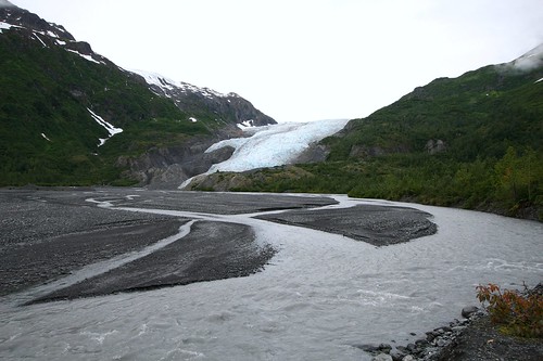
Exit Glacier, the location that served as the exit for the first recorded crossing of the Harding Ice Field.

Exit Glacier


As you drive out of Seward (or into Seward...there is only one road), you pass a spur that will lead you to Exit Glacier. This spur is the only road that lies within the Kenai Fjords National Park. As you drive down this spur you pass several odd signs that show nothing but four digit numbers. We later learned that those four digit numbers were years, and they marked where Exit Glacier terminated at various points in the past. I cannot remember what the exact year was on the first sign we passed, but it was somewhere in the late 1800's. Once we learned what the numbers represented, we immediately wondered how they knew where the glacier terminus was that long ago?"

Part of the answer turns out to be forest succession. As Exit Glacier recedes it leaves bare ground. Eventually, that bare ground is covered by plants, and then over time, different plants replace the previous plants. It turns out that the order in which plants cover that bare ground and replace each other is fairly predictable. By looking at what is growing at various distances from the current terminus of Exit Glacier, and how old those things are, you can estimate how many years it has been since the terminus was at that point. If my slim explanation of forest succession leaves you wanting more, you can read better explanations of forest succession here and here (PDF).

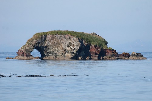
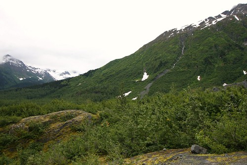
This next picture was my attempt at capturing evidence of forest succession. On the opposite ridge, you can see "lines" in the vegetation that draw a crude outline of where the edges of Exit Glacier were at some point in the past. As you follow the opposite ridge from right to left, near the left edge of the photo the height of the vegetation suddenly increases, giving a clue to where Exit Glacier previously terminated. Also, as you go up the opposite ridge the type of vegetation changes, giving a clue to the height of Exit Glacier at some point in the past. If you are not sure what I am referring to, then click the picture (or here) and it will take you to my Flickr page for this photo where I used the "note" feature of Flickr to point out these "lines".

Exit Glacier Forest Succession


At the end of the spur road, there is a visitor center and a couple trail heads (the National Park Service provides an interesting birds eye view map (PDF) using an aerial photograph). One trail leads you to the top of the ridge where Exit Glacier slowly oozes out of the Harding Ice Field. That sounded immensely interesting, but we did not have the time to invest for that hike. Instead we chose the very easy and quick trail to the terminus of Exit Glacier. Although they do not allow you to walk up and touch the glacier (too much risk of a chunk of ice breaking off and landing on you), you can get close enough to feel the cold of the ice.

Exit Glacier


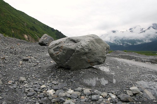
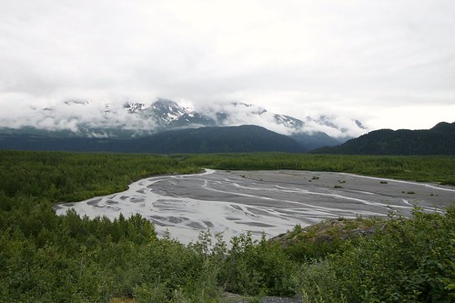
Here are two more photos, these with the glacier at my back. The first shows a nice sized chunk of rock that was left by the glacier. The second shows the outwash plain (or sandur) of the glacier.

Exit Glacier Debris


Exit Glacier Outwash Plain

Time Out

I am taking a break from the Alaska photos this week to share a picture or two that I took this past weekend at Dutch Gap Conservation Area (DGCA). Nothing fancy, but it will take a little less time on my part during a week that has a lot less time available for blogging.

DGCA built a bridge this past winter that turned an eight mile out and back into a five mile loop. The weather was really nice this past Saturday, so Tammy and I went out and hiked the new loop. Along the way we found this Great Blue Heron posing ever so nicely next to the far shore.

Great Blue Heron