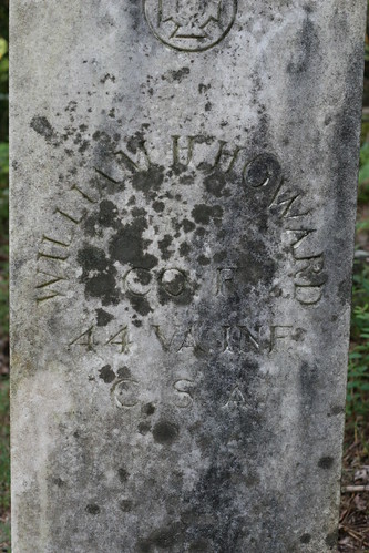
Despite the additional mileage, this was a great hike. It was a warm day and we finished very tired, but there were good things to be seen the entire hike. For example, as I mentioned above, the variant hike began at Browns Gap, following the old Browns Gap Turnpike down the mountain. It is now a fire road for the park, but it was originally constructed by the Brown family to move produce. During the Civil War, however, it was used by Stonewall Jackson to move troops. A little ways down the old road, there was a clearing on the left side where someone had taken care to preserve a grave marker. There is no date on the marker, but the individual, one William H. Howard, succumbed to something on this road and was laid to rest here. According to the marker (and this web page), he was in Company F ("The Fluvanna Hornets"), of the 44th Virginia Infantry, of the Confederate States Army.
Eventually the old turnpike crosses the Doyles River Trail. We turned right on it and followed it down, past a couple "could have been nice" waterfalls until it turned into Jones Run Trail and began to ascend. This took us back up the mountain, again past several "waiting for rain" waterfalls, until we got to the Appalachian Trail. We then followed the Appalachian Trail back to the car at Browns Gap.
The number of significant waterfalls on this hike makes it something to return to at some point in the future. On this day, there just was not very much water flowing in the streams. A couple of the waterfalls were just rock walls with no water. In the future, when the weather has not been so dry, a return trip should allow us to see water falling.
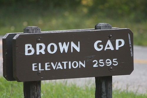
Here are a couple of photos from the start of the hike. The first shows the sign for "Brown Gap". All the books, and online maps, show this as "Browns Gap", but the sign on the Skyline Drive did not include the "s" on "Brown" for some reason. The second photo is of the grave marker I described above.
No comments:
Post a Comment